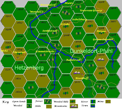
 Here's a small part of the campaign map for the wars between the Grand Duchy of Hetzenberg and the Margravate of Dunkeldorf-Pfühl. The major (as yet unnamed) river forms the main border between the two, and flows south-to-north. The extract shows "the Cockpit," a broad valley centered around the town of Kimmelsbrücke which has an important fortified bridge. The uplands to the west of the town are rich in mineral resources, and a silver mine is shown near the town of Ebenstadt.
 *
To the east lie the Margravate lands with the Vauban-fortified town of Randstadt. The town guards the choke-point formed by the confluence of two river valleys which lead in turn to fertile plains country further to the east (off the map). On the hills above these valleys lie the towns of Blankhoff with its iron mine, and Helgau with a coal mine. *
Coal, iron and silver - three minerals which have plenty of applications for warfare - and a broad valley just right for military maneuvers. With tensions rising between the two nations, the valley of the Cockpit may soon be living up to its name...


6 comments:
Hi AJ,
Hey, I really like this map excerpt. Just enough color and detail without appearing overly fussy. Very nice work!
Best Regards,
Stokes
I agree with Stokes. Nice map to start a campaign with.
A cool map; I like it.
Since the area has deposits of iron ore, why not call your river either the Eisen or Eisenwasser?
(note: eisen is a German word for iron).
-- Jeff
Thank you, gentlemen. I intend to map out the terrain and human features on paper, and transpose them onto a hexagon mapping template on my PC. As and when the campaign gets under way and battle is joined, I can post excerpts of the field of war.
Eisenwasser... I like it! =) Thank you kindly, Jeff.
So you did this map yourself in a program or was it done with the help of a 'mapping' program of some sort?
Murdock, this particular map was derived from the Traveler rpg map blanks. I scanned it into my PC and modified the size of the hexagons using the basic Paint program. Everything else from the numbering to the terrain features was also done this way.
It needs a certain amount of refinement (the hexagons are misaligned in places) but when I've done this I'll gradually expand the size of the map until it covers the entire campaign area.
Post a Comment